Los Angeles launches new interactive transportation map
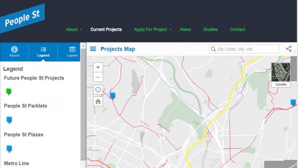
Los Angeles residents now have access to a web map that gives them a clear view of the city's current and future streetscape projects such as sidewalk expansions and bicycle parking.
The Los Angeles Department of Transportation (LADOT) launched the web map, built on the Esri ArcGis platform, earlier this month. The map pulls City of Los Angeles, Los Angeles County Metropolitan Transportation Authority (Metro) and County of Los Angeles data into a single view, providing an overall picture of the City’s transportation infrastructure network, as well as parks and other public open space, according to a LADOT press release.
“This kind of information can often appear complex and confusing with other mapping tools,” Valerie Watson, LADOT active transportation planner and urban designer, said in a written statement. “ArcGIS Online makes it easy to digest this data in incredibly informative ways.”
The web map complements the city’s People St program, which invests in low-cost, high mobility street design projects, according to GIS Users. Elected officials and residents can apply through People St for improvement projects that can transform the city’s underused space – equating to about 7,500 miles of streets – into parklets, bicycle corrals and plazas.
GIS Users reports that the People St program is one tool LADOT is using to achieve the goals of Mayor Eric Garcetti’s Great Streets Initiative as well as the city’s Mobility Plan 2035, a vision for Los Angeles of an enhanced system of transportation infrastructure that can prioritize and improve the city's transportation modes including the rail system, cycling and walking.
“Minor changes in how we balance streets so they are more conducive to multimodal transportation choices – such as people walking, bicycling, taking transit and enjoying the sidewalk environment – have positive effects on neighborhoods, from business vitality to social gathering,”Watson said. “The power of the map is that it allows people to explore how current and future People St projects fit into and enhance the bigger picture of mobility in Los Angeles."
_____________
To get connected and stay up-to-date with similar content from American City & County:
Like us on Facebook
Follow us on Twitter
Watch us on Youtube


